
The 83 miles of shoreline along the south shore of Long Island, NY, between Fire Island Inlet and Montauk Point, has experienced serious erosion over the years, destroying residential homes, negatively impacting shorefront communities, and adversely affecting national economic development.
The objective of the ongoing Fire Island Inlet to Montauk Point (FIMP) project is to reduce risks associated with coastal storms within the study area, as well as to reestablish and enhance the natural coastal processes that replenish beaches and enhance ecological resilience. The recommended plan consists of inlet sand bypassing, beach and dune (re)nourishment, groin modifications, coastal process features, nonstructural measures, and adaptive barrier island breach response plans. The project is currently in design and construction.
For more information please read the Fire Island Inlet to Montauk Point Project Fact Sheet
Click here to view the overall project presentation
Project Area
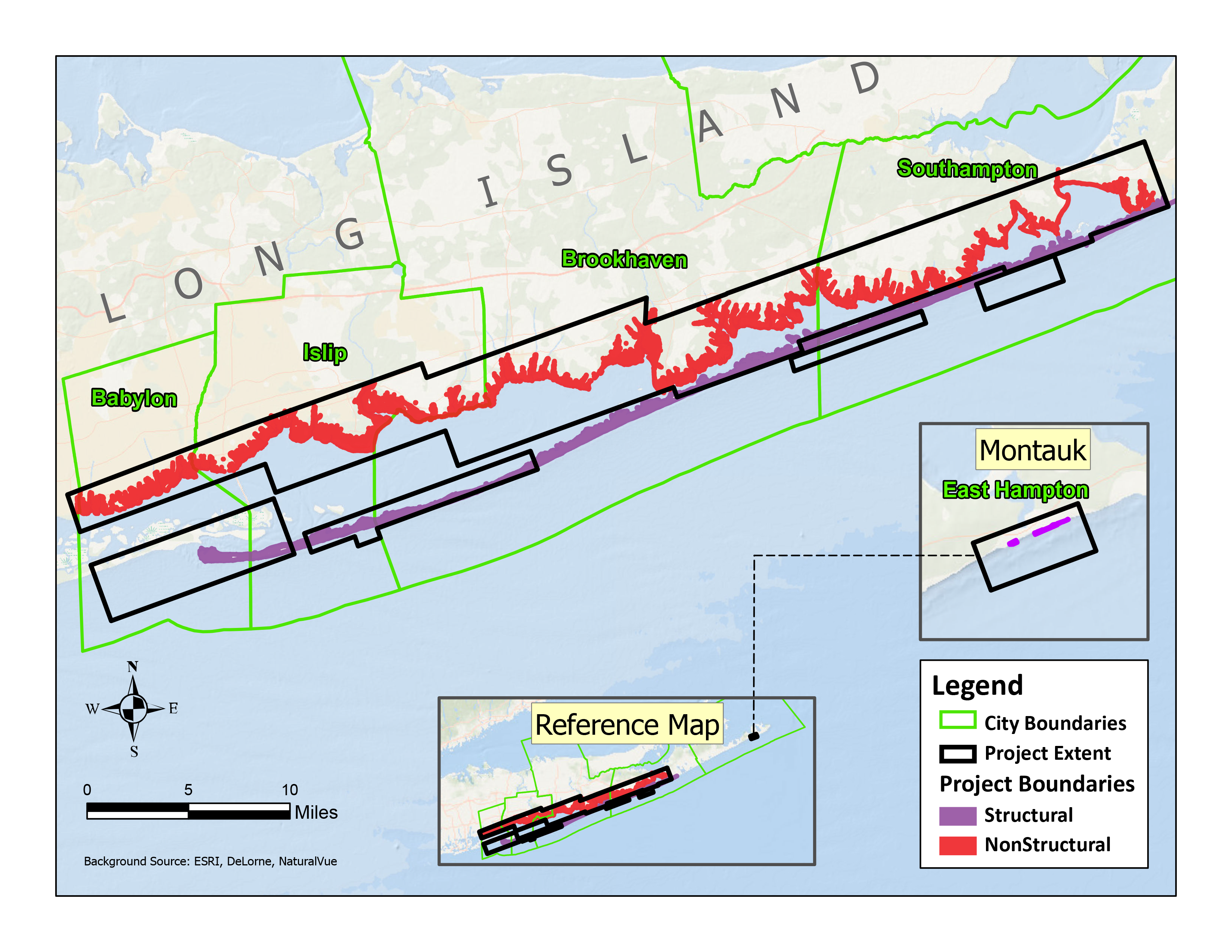
The Fire Island Inlet to Montauk Point project area extends from Fire Island Inlet to Montauk Point along the Atlantic Coast of Suffolk County, spanning a distance of approximately 83 miles, comprising about 70 percent of the total ocean frontage of Long Island. It includes the barrier island chains from Fire Island Inlet to Shinnecock Inlet, a shorefront area east of Shinnecock Bay to Montauk Point, and adjacent back-bay areas along Great South, Moriches, and Shinnecock Bays. The study area includes portions of the Towns of Babylon, Islip, Brookhaven, Southampton, and Easthampton, as well as 12 incorporated Villages, the entirety of the Fire Island National Seashore (FIIS), the Poospatuck Indian Reservation, and the Shinnecock Indian Reservation. Over 46,000 residential and non-residential structures (which includes critical infrastructure such as schools, hospitals, firehouses, and police stations) are located within the project area. More than 9,000 of these structures, and approximately 150,000 residents are within the present day 1-in-100-year coastal floodplain. The project area is also a popular summer recreation area with a large seasonal influx of beachgoers and visitors, as well as businesses which support the year round and seasonal population of the area.
Click here to see the project placemat
Contracts
The FIMP project consists of 11 separate contracts as outlined below.
Contract 1: Consists of dredging of Fire Island Inlet and Shoals, with placement of sand (approximately 1.5 MCY) at Gilgo Beach and Robert Moses State Park. This work was completed in April 2023. See the SAM.GOV notice for more details.
Contract 2: Consists of dredging Moriches & Shinnecock inlets, with placement at coastal process features (CPFs). This work was completed in May 2023. See the SAM.GOV notice for more details.
Contract 3: Consists of dredging offshore borrow sites. Contract 3a, was competed under a separate contract as part of the Fire Island to Moriches Inlet (FIMI) project via a PL 84-99 contract. Contract 3b consists of sand placement in Southampton. See the SAM.GOV notice for more details.
Contract 4: Consists of dredging offshore borrow sites and sand placement.
Contract 5: Consists of groin modification at Ocean Beach.
Contract 6-10: Consist of nonstructural measures throughout the project area. See the nonstructural page for more details.
Contract 6: Pilot project for nonstructural measures (year 1). Pilot areas include bayfront communities in Mastic Beach and Frederick Shores in Babylon.
Contract 7: Year 2 of nonstructural measures. This contract is anticipated to include up to 1,000 structures.
Contract 8: Year 3 of nonstructural measures. This contract is anticipated to include up to 1,250 structures.
Contract 9: Year 4 of nonstructural measures. This contract is anticipated to include up to 1,250 structures.
Contract 10: Year 5 of nonstructural measures. This contract is anticipated to include up to 450 structures.
Contract 11: Initial construction of coastal process features.
PL 84-99 Emergency Work Authorized
P.L. 84-99 establishes USACE authority to provide emergency activities in support of state and local governments prior to, during, and after a flood event. Under this authority, a project information report (PIR) is required to secure funding to repair an existing USACE project damaged by an eligible event.
In January 2020, a PIR was completed, authorizing repairs for a portion of Fire Island from Saltaire to Seaview. The authorized repair work was recently completed in February 2024.
In February 2024, an additional PIR was completed, authorizing repairs for a portion of Fire Island from Ocean Bay Park through Davis Park and the and eastern portion of Seaview.