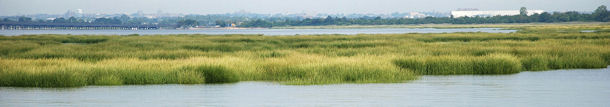
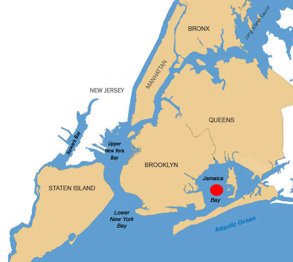
Jamaica Bay is situated within the boroughs of Brooklyn and Queens, New York City. Approximately 8 miles long by 4 miles wide, it covers 26 square miles, and opens into the Atlantic Ocean via the Rockaway Inlet. Jamaica Bay is recognized by the U.S. Fish and Wildlife Service as a coastal habitat deserving preservation and restoration of habitats which contribute to sustaining and expanding the region's native living resources. Jamaica Bay is a highly productive habitat for a variety of fish and wildlife species. These species breed and use the area as a nursery for juvenile birds that reside in the area during winter, and for migratory birds that stop-over during the fall and spring seasons.
The Jamaica Bay Marsh Islands are at the heart of the complex urban ecosystem of Jamaica Bay that is a part of the U.S. Department of the Interior, National Park Service - Gateway National Recreation Area, the first urban national park established in 1972, and is a key component of the President's America's Great Outdoors initiative.
The marsh islands complex is an integral part of the Jamaica Bay ecosystem that has been targeted for restoration. It is estimated that approximately 1,400 acres of tidal salt marsh have been lost from the marsh islands since 1924, with the system wide rate of loss rapidly increasing in recent years. From 1994 and 1999, an estimated 220 acres of salt marsh were lost at a rate of 47 acres per year. Left alone, the marshes were projected to vanish by the year 2025, destroying wildlife habitat and threatening the bay's shorelines.
To date, there is no consensus among ecological experts on the cause of the erosion of the marsh islands, which range from rising sea levels and warmer temperatures to nitrogen input from storm water run-off. Representatives from federal, state and local agencies have helped to jumpstart the ecological process acknowledging that these daunting challenges to restoring an urban estuary need to be overcome.
In response to these losses, under the U.S. Army Corps of Engineers' Continuing Authorities Program (CAP), the New York City Department of Environmental Protection and the New York State Department of Environmental Conservation requested assistance in implementing one or more marsh island restoration projects.
A 2006 report titled "Jamaica Bay Marsh Islands, Jamaica Bay, NY, Integrated Ecosystem Restoration Report" recommended restoration of three marsh islands: Elders Point East, Elders Point West and Yellow Bar Hassock.
As of 2005, Elders Point was comprised of two islands, Elders East and Elders West totaling only 21 vegetated acres. Originally one island comprised of 132 acres, the loss of marsh in the center portion severed the two ends, resulting in two separate islands connected by mudflat.
U.S. Army Corps of Engineer activities at Elders Point East Marsh Island in 2006-2007 involved restoring 40 acres of marsh constructed for mitigation purposes to offset environmental impacts of the New York & New Jersey Harbor Deepening Project.
In 2010, the U.S. Army Corps of Engineers, in partnership with the Port Authority of New York and New Jersey, the New York State Department of Environmental Conservation (NYS DEC), the New York City Department of Environmental Protection (NYC DEP) and the National Park Service (NPS) restored approximately 40 additional acres at Elders Point West as a result of the beneficial use of dredged material from the HDP.
The restoration plan for Elders East and West included restoring the existing vegetated areas and the sheltered and exposed mudflats by placing dredged sand up to an elevation suitable for low marsh growth. This included hand planting more than 700,000 plants (grown from local seed stock by the National Resources Conservation Service (NRCS) on East and replanting more than 200,000 plants on West.
On Elders East, smooth cord grass or salt marsh cord grass (Spartina alterniflora) was planted throughout the low marsh zone. A mixture of salt marsh cord grass, salt meadow cord grass or salt hay (Spartina patens), and spike grass (Distichis spicata) were planted in the zones between low marsh and upland.
As part of the New York/New Jersey Harbor-Jamaica Bay Multi-Project Initiative, sand from the Ambrose Channel was beneficially reused from the Harbor Deepening Project to create an additional 87 acres of marsh island habitat within Jamaica Bay.
During February and March 2012, 375,000 cubic yards of sand was placed at Yellow Bar Hassock Marsh Island resulting in 67 acres of new marsh island and approximately 45.4 acres of wetlands, including ~ 13.3 acres of hummock relocation. Twenty eight acres of low marsh seeding, 17,175 high marsh plants, and 21,859 high marsh transition plants. Marsh construction was completed on 2 August 2012. Replanting damaged/lost vegetation from Hurricane Sandy will take place in the Spring of 2014.
In September and October 2012, Ambrose Channel sand was also beneficially used to restore an additional 30 acres of marsh islands at Black Wall (155,000 cubic yards of sand, 20.5 acres) and Rulers Bar (95,000 cubic yards of sand, 9.8 acres) as part of the U.S. Army Corps of Engineer’s Beneficial Use Program with local partners the New York State Department of Environmental Conservation, the New York City Department of Environmental Protection, and The Port Authority of New York and New Jersey.
 The New York State Department of Environmental Conservation, the New York City Department of Environmental Protection with the local non-profit organizations EcoWatchers, Jamaica Bay Guardian and the American Littoral Society, completed a community-based planting effort to vegetate 30 new acres created at Black Wall and Rulers Bar with the above referenced plants in June 2013.
The marsh island restoration efforts are being monitored by a project team that is providing valuable data on the cause of problems and assisting to identify optimum effective future restoration options. This program also has significant implications for the future success of restoration activities from beneficially using sand from the Operations and Maintenance (O&M) Program.
SUMMARY OF MARSH ISLAND WETLAND ACRES RESTORED
Elders East …………….. Approximately 40 acres
Elders West …………… Approximately 40 acres
Yellow Bar Hassock ...... Approximately 45 acres
Black Wall …………….. Approximately 20 acres
Rulers Bar ……………… Approximately 10 acres
For information, contact: Lisa Baron, Project Manager
Email: lisa.a.baron@usace.army.mil
Telephone: 917-790-8306