The success of ocean commerce within the Port of New York and New Jersey depends on a regular and predictable program of maintenance and new work dredging. Dredging is required to remove shoals that interfere with safe navigation due to the settlement and accumulation of fine-grained sediments that are transported to the estuaries by rivers. If the viability of the Port is to continue, existing navigation channels, berthing areas and anchorages must be maintained to ensure safe clearance depths, and deeper navigation channels must be excavated to accommodate modern cargo ships.
Using dredged material from the Harbor to cover existing sediments at the Historic Area Remediation Site (HARS) represents an environmentally beneficial use of this resource.
Bottom sediments at the HARS which have the potential to cause adverse effects are capped with cleaner Harbor dredged sediments that meet the criteria of the Ocean Dumping Act and will not cause adverse effects. Placement of this material at the HARS is remediating the site by reducing impacts from earlier disposal events to acceptable levels; thereby improving habitat conditions for bottom dwelling organisms.
Mud Dump Site History
Since the mid-1800s materials including garbage, city refuse, cellar dirt (natural rock and soil excavated during building construction), floatable materials, and sediments derived from dredging during the maintenance, deepening and construction of new navigation channels in New York Harbor, were dumped at specific locations in the New York Bight Apex. Records indicate that approximately six locations were selected to receive this wide range of materials. As the material accumulated at these locations, the sites were relocated farther seaward where increased water depths alleviated concerns of potential navigation threats posed by accumulation of materials.
The Office of Supervisor of New York Harbor was established by an act of Congress in 1888 to address the increasing need for disposal of the assorted waste materials from the harbor. The Harbor Supervisor, acting through the Office of the Chief of Engineers (of the U.S. Army Corps of Engineers), was responsible for the designation of specific disposal sites and for ensuring that ocean disposal would not be detrimental to navigation or pollute adjacent beaches.
Hydrographic data spanning the period from 1845 to 1934 revealed that mounds of material were being formed in the general area of the submerged Hudson Shelf Valley (Christiaensen Basin), the Ambrose Light Station (Diamond Hill), and the Scotland Light Buoy. By 1914, shoaling at one of the sites reserved for dredged material and cellar dirt became a critical factor in the decision of the Supervisor of New York Harbor to separate the site usages and thus segregate the material being disposed at each site.
From 1914 until 1977, when the U.S. Environmental Protection Agency (EPA) designated an interim ocean dredged material disposal site, the general area reserved specifically for a "mud dumping ground" was defined as a point not less than 7 nautical miles bearing 120° from Sandy Hook Light at Latitude 40° 23'48" N and Longitude 73° 51'21" W. The boundary coordinates of the 2.2 square nautical mile (sq. nmi) interim site that became the MDS, were:
• 40° 23'48" North Latitude, 73° 51'28" West Longitude
• 40° 21'48" North Latitude, 73° 50'00" West Longitude
• 40° 21'48" North Latitude, 73° 51'28" West Longitude
• 40° 23'48" North Latitude, 73° 50'00" West Longitude
During those sixty-three years of disposal it is estimated that more than 200 million cubic yards (MCY) of dredged material were deposited there. An analysis of bathymetric change from 1936 to 1995 shows that significant mounding occurred in the area, with a net volume increase of 190 MCY over that period. Although open ocean bathymetric surveys are subject to large potential errors, this volume change indicates an average of 3.2 MCY of dredged materials per year were disposed.
In 1984, EPA officially designated the interim site as a dredged material ocean disposal site, referring to it as the “Mud Dump Site” (MDS). From 1976 to 1997, when more reliable disposal volume records were kept, approximately 115 MCY of dredged sediment were disposed within the boundaries of the MDS. The composition of this material varied from the coarser fraction of "one-man stone" and "derrick stone" to the finer grained material - sand, silt and clay. The wide variety of bottom sediment types supported a diverse ecosystem. Beginning in mid-1991, the larger stones were directed to artificial reef sites to extend the useful life of the MDS for accommodating the sand and silt materials that are most commonly dredged from harbor navigation projects.
Establishment of the HARS
In September 1994, EPA began preparing a Supplemental Environmental Impact Statement (SEIS) in an effort to expand the boundaries of the MDS. The study area was initially comprised of an 18 sq. nmi section that included and surrounded the MDS. The study area was enlarged in October 1995 to 23 sq. nmi to encompass areas of the Apex which had been previously impacted by historic dredged material disposal.
Because of concerns about contaminants associated with some dredged materials, a July 24, 1996 letter (The 3 Party Letter), signed by EPA Administrator Carol Browner, Secretary of Transportation Frederico Pena, and Secretary of the Army Togo D. West, Jr., to several U.S. Congressional Representatives from New Jersey, called for the closing of the MDS and the establishment of a remediation area within the study area.
In September 1997, the EPA de-designated and terminated the use of the MDS and simultaneously re-designated the site and surrounding areas that had been historically used for dredged material disposal as the Historic Area Remediation Site (HARS) (40 CFR Sections 228.15(d)(6); see 62 Fed. Reg. 46142 (29 August 1997); 62 Fed. Reg. 26267 (13 May 1997)). The need to remediate the HARS was supported by the presence of toxic effects, dioxin bioaccumulation exceeding Category 1 levels in worm tissue, as well as TCDD/PCB contamination in area lobster stocks. Although individual elements of those data did not establish sediments within the HARS as imminent hazards to the New York Bight Apex ecosystem, living resources, or human health, the collective evidence presented cause for concern and justified the need for remediation. Further information on the conditions in the Study Area and the surveys performed may be found in the SEIS (EPA, 1997). The HARS is managed to reduce impacts of historical disposal activities at the site to acceptable levels in accordance with 40 CFR Section 228.11(c).
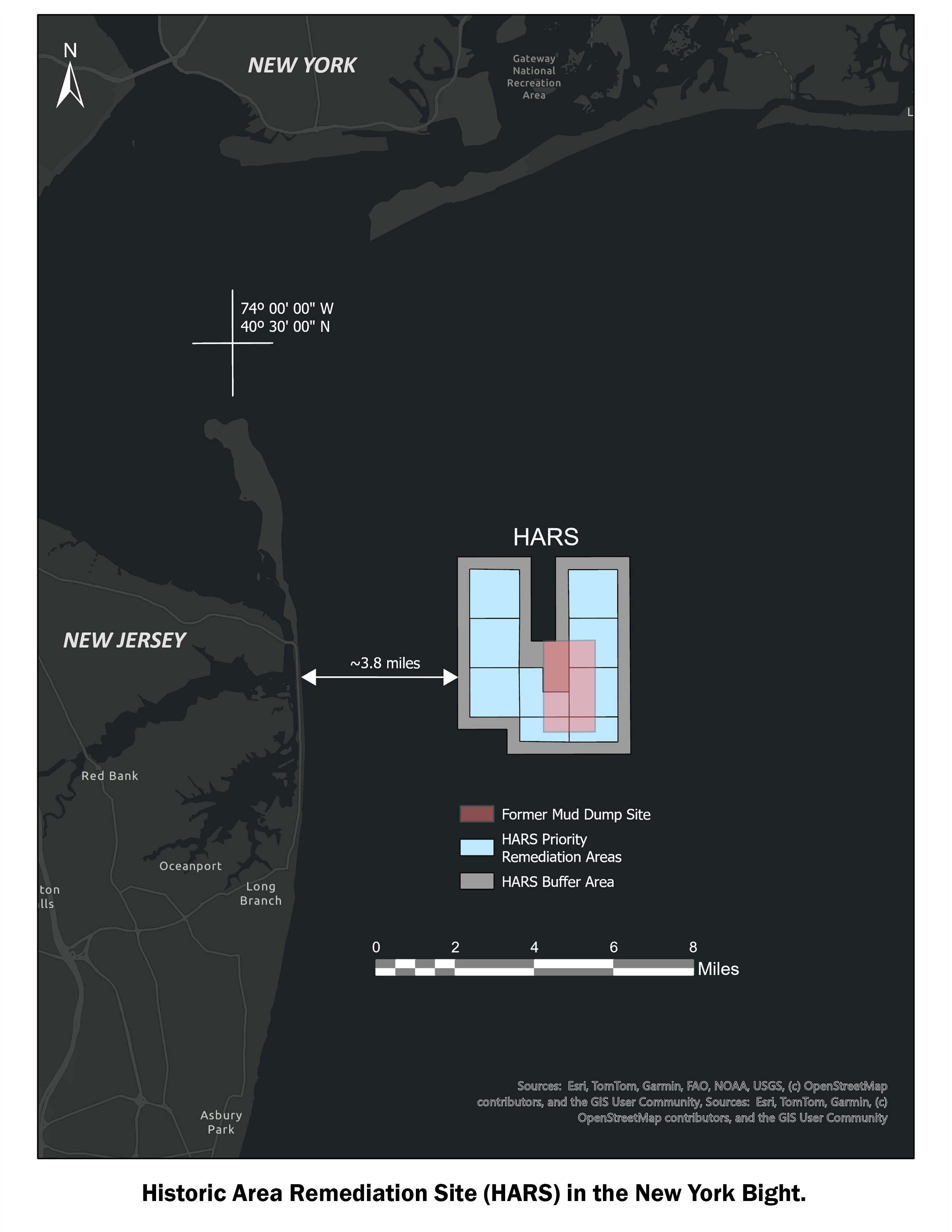
The HARS designation identified an approximately 15.7 square nautical mile area located approximately 3.5 nautical miles east of Highlands, New Jersey and 7.7 nautical miles south of Rockaway, New York area in and around the MDS which had exhibited the potential for adverse ecological impacts (see Figure 1). The HARS is being remediated with dredged material that meets current Category 1 standards and does not cause significant undesirable effects including through bioaccumulation. This dredged material is referred to as "Material for Remediation" or "Remediation Material.” Proposed dredged sediment is determined to be Category 1 if test results indicate no unacceptable toxicity or bioaccumulation in test systems per the guidelines and requirements listed in the US Army Corps of Engineers, New York District and EPA Region 2 – Guidance for Performing Tests on Dredged Material Proposed for Ocean Disposal (April 2016).
The HARS includes the following three areas (see Figure 2):
Priority Remediation Area (PRA): An approximately 9.2 square nautical mile are to be remediated with at least 1 meter of Remediation Material. The PRA encompasses the area of degraded sediments as described in greater detail in the SEIS.
Buffer Zone: An approximately 5.7 square nautical mile area (0.27 nautical mile wide band around the PRA) in which no placement of the Material for Remediation will be allowed, but may receive Material for Remediation that incidentally spreads out of the PRA.
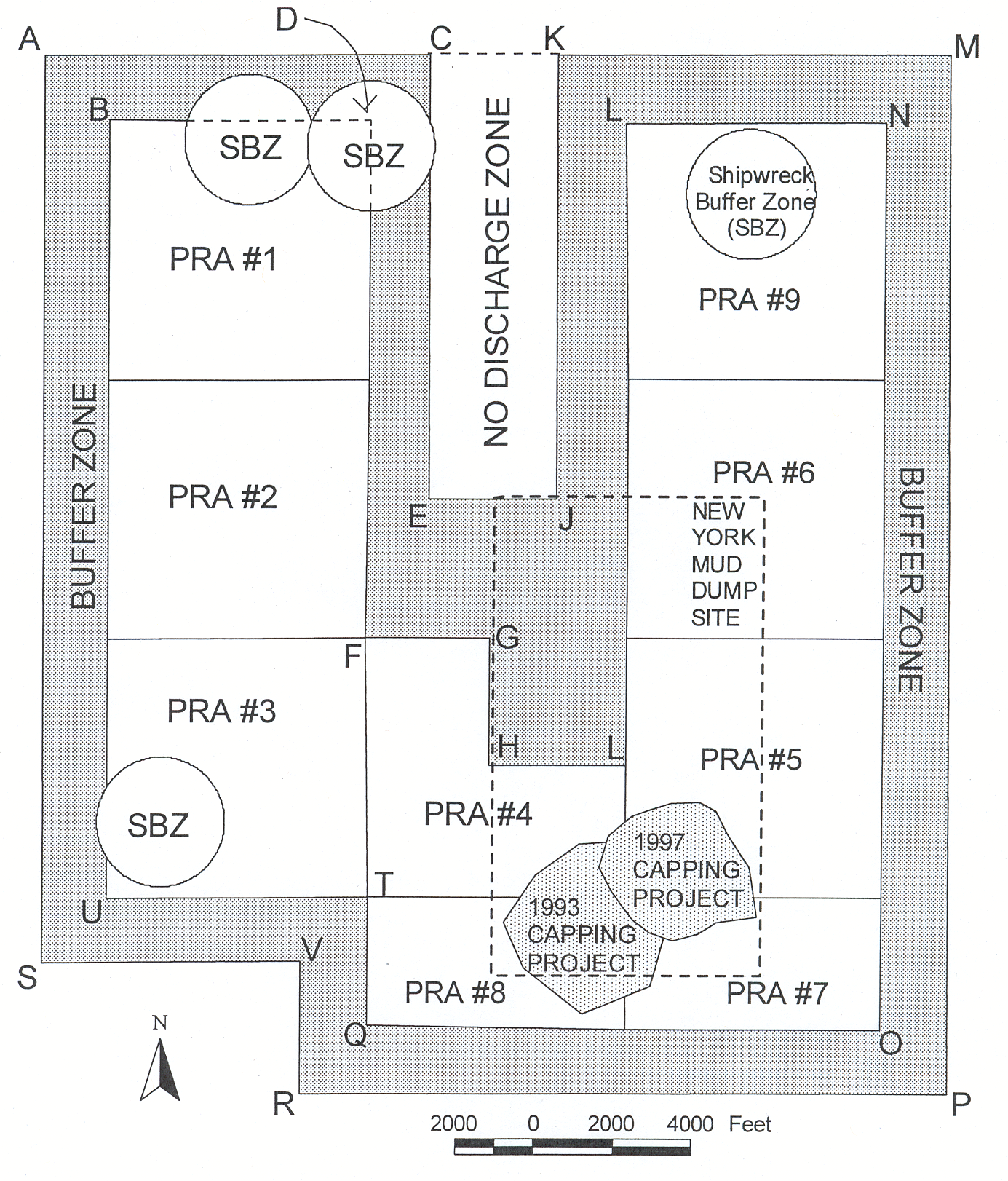 No Discharge Zone: An approximately 1.0 square nautical mile area in which no placement or incidental spread of Material for Remediation is allowed.
As of 30 September 2019, approximately 76 MCY of dredged material from 127 dredging projects have been used to remediate the HARS since designation. In addition, approximately 2.4 MCY of sand were used to cap the 1997 Category II project at the former MDS from 21 August 1997 to 18 January 1998.
Dredged Material Placement and Permit Compliance Monitoring
When a dredging project is approved for HARS remediation, a specific area of the HARS is selected for its placement within one of the nine PRAs based on the status of past and present remediation at the HARS. The estimated volume and sediment characteristics of the dredged material are used to develop placement grids that will produce uniform 0.5-foot to 3-foot coverage across the area of the grid, depending on the characteristics of the dredged material (coarser materials do not spread out much on the bottom). Grids are divided into sequentially numbered cells to ensure uniform coverage. Grids are located far enough from the HARS boundaries to ensure that water quality guidelines outside the HARS are not exceeded during placement. A state-of-the-art electronic monitoring system is used to track the position of dredged material scows being transported to and discharging materials at the HARS.
The Automated DIsposal Surveillance System (ADISS), is a dGPS (differential global positioning system)-based vessel position and draft monitoring system used to monitor scows placing Remediation Material at the HARS. The heart of the system is a "black box" recorder mounted on each scow used to transport dredged materials to the HARS. The "black box" digitally records the time and position of scows as they are loaded with dredged materials at the dredging site based on the increase in scow draft recorded by a pressure sensor on the scow. The ADISS system records the time, position, and draft of the scow throughout each trip. A scow bin-level sensor is also used to help detect potential leaks of dredged material from scows transporting high water content sediments (typically maintenance dredged material). As the HARS is approached, the frequency of data recording increases. At the time of placement, when the scow draft rapidly decreases as dredged materials are emptied, the position and time information is transmitted through a wireless transmission system to a computer for eventual viewing on a website. The ADISS system continues to record the time, position, and draft data past the initial scow door opening, during placement, and throughout the trip back to the dredging site.
Scow navigation capability aboard towing vessels is another feature of the ADISS system. The ADISSPlay component allows USACE-certified Dredged Material Inspectors (DMIs) and vessel captains, to view the position of scows on a laptop computer throughout the trip to the HARS. Placement grids designated for each project are projected on a map of the inner New York Bight and NY/NJ Harbor region. DMIs can zoom in or out of the map view to observe the position of the scow relative to landmarks, navigation aids, and the grid cell scheduled for placement. A digital version of the USACE Transportation and Placement Log form is included with the system, which the inspector completes during each trip to the HARS.
This compliance monitoring has resulted in several enforcement actions by the Corps and EPA.
Monitoring Activities at the HARS
A Site Management and Monitoring Plan (SMMP) for the HARS was developed by US Army Corps of Engineers, New York District and EPA Region 2 prior to HARS designation according to the provisions of 40 CFR part 228. The HARS SMMP provides guidelines to monitor placement activities, assess the progress of remediation, analyze environmental conditions, and address potential environmental issues. The HARS SMMP specifies three tiers of monitoring, with different criteria for implementation of monitoring activities associated with each tier. The HARS SMMP was updated in 2000, 2010 and in 2020 to reflect technological improvements in placement procedures and completed remediation activities.
Bathymetric Analysis
Although remediation progress can be estimated based on the size of each project grid and the volume of material placed, bathymetric surveying is the only quantitative way to document the thickness of cover associated with dredged material placement. Bathymetric surveys have been conducted annually since HARS designation and have included surveys of the entire HARS and surveys of one or several PRAs.
Side-scan Sonar Surveys
Side-scan sonar is analogous to bathymetric surveying in that sound is transmitted from a survey vessel, bounces off the bottom, and returns to a receiver. The time for the sound to make the round trip is proportional to the distance, which equates to water depth. However, side-scan sonar uses sound to obtain the distance and reflective characteristics of bottom features, providing images that look like photographs. Side-scan sonar is considered a qualitative tool, providing the general location and morphology of bottom features, but usually without the precision of bathymetric surveys. When side-scan and multibeam bathymetric surveys are conducted concurrently, exquisite detail of the bottom may be documented. Past side-scan sonar surveys at the HARS have been used to identify rock outcrops, large sedimentary bedforms, and shipwrecks. Since HARS designation, multiple side-scan sonar surveys have been conducted of the entire HARS.
Sediment Profile and Plan View Imaging Surveys
The sediment profile imagery (SPI) system utilizes a prism that penetrates the seafloor, allowing photography of nearly undisturbed vertical sections of bottom sediments. The apparatus also includes a camera for obtaining plan-view photographs of the bottom at each station analyzed. SPI images are most useful in delineating the contact between recently placed dredged materials and older bottom sediments. SPI images can also document infaunal organisms, gas bubbles, and sediment grain size. The rapid deployment capability of the SPI systems allows large areas to be surveyed in a relatively short amount of time. SPI imagery has been particularly useful in mapping the dredged material "footprint" associated with past dredged material placement. Several SPI surveys have been conducted at the HARS.
Seismic Surveys
Seismic data are used to map the sedimentary units beneath the ocean surface based on the sound reflection and transmission characteristics of the sediments. Although cores provide discrete samples of sub-surface sedimentary information, their time and expense limits the practical number of sample stations. Seismic data allow analysis of large areas of the sub-surface without physically collecting sediment samples, although cores are often used to calibrate and verify seismic data. A seismic survey of the 1997 Category II capping project was conducted in April 1998. Seismic surveys of the 1993 and 1997 capping projects were conducted in 1998 and 2003.
Surficial Chemistry, Toxicity, and Bioaccumulation Surveys
Samples of surficial sediment have been taken from remediated and unremediated areas of the HARS to gauge various indicators of benthic condition. Measures include sediment physical and chemical characteristics (e.g., total organic content), contaminant levels in sediments and resident worms, and sediment toxicity and benthic community composition. Prior to designation of the formal HARS boundaries, amphipod toxicity was one of the data types used by EPA to determine areas of degraded sediments requiring remediation. The amphipod toxicity test is one of the tests used to determine whether proposed dredged sediment can be used as Remediation Material. Toxicity surveys conducted at the HARS are used to gauge the effectiveness of the remediation effort. In general, sediment toxicity at the HARS is lower at almost all stations than was observed at the same stations prior to HARS designation.
Remediation Status
By comparing recent bathymetric surveys with past surveys, the depth of remediation material at the HARS can be analyzed. Almost all of HARS PRAs #1, #2 and #3 have been capped with at least 1-m of Remediation Material. Most of HARS PRAs #4 and #8 have also achieved the minimum 1-m cap thickness. Large portions of PRAs #5, #6, #7 and #9 have not yet been covered with at least 1-m of Remediation Material.
Additional Information