DESCRIPTION: Designated in 1997, the Historic Area Remediation Site (HARS) is comprised of a 15.7 nautical square mile area located approximately 3.5 nautical miles east of Highlands, New Jersey and 7.7 nautical miles south of Rockaway, New York. The HARS is an active remediation site where at least one meter of dredged material that meets Category 1 ocean disposal criteria, also referred to as “Remediation Material,” is placed to remediate impacted areas in and around the former Mud Dump Site (MDS) which is within the footprint of the HARS. Any Remediation Material placed at the HARS is tested and must pass stringent criteria established for the HARS. Acceptable Remediation Material is typically generated from maintenance and new work dredging of Federal Navigation Channels and anchorages, as well as private berths, in the vicinity of NY/NJ Harbor. To date, approximately 84 million cubic yards of Remediation Material has been placed at the HARS. As the HARS approaches remediation completion, alternative placement site(s) are needed to provide capacity for dredged materials generated from planned maintenance and deepening projects.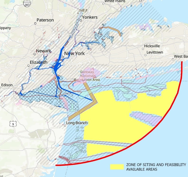
USACE-NYD has determined over the next 20 years, the dredging/disposal needs will exceed the existing capacity at the HARS and upland placement sites. The projected need for dredged material placement over the next 20 years is approximately 51 million cubic yards including Harbor Deepening Channel Improvement (HDCI), Federal navigation maintenance projects and permitted private projects. On June 1, 2023, USACE-NYD formally requested EPA Region 2 to begin the Ocean Dredged Material Disposal Site (ODMDS) designation process, to provide for future management of dredged material necessary to maintain safe navigation, promote marine commerce, and safeguard the economic well-being of the region.
USACE-NYD conducted, a Zone of Siting Feasibility (ZSF) analysis to identify the economic and operationally feasible radius of ocean placement sites. Initially, the ZSF establishes an economically feasible radius for disposal site locations extending 40 miles from a central point within the Port. Within that radius, environmentally sensitive and restricted areas were removed. These areas include, but are not limited to, marine protected areas, artificial reef sites, shallow areas, navigational channels and shipping approaches, submarine cable crossings, etc. The remaining area within the economically feasible radius that avoids these excluded areas is shown as a yellow area in Figure 1.
AUTHORIZATION: Section 102(c) of the Marine Protection, Research, and Sanctuaries Act of 1972 (MPRSA), as amended, 33 U.S.C. 1412, gives EPA the authority to designate sites where ocean disposal may be permitted. On October 1, 1986, the Administrator delegated the authority to designate ocean dredged material disposal sites to the Regional Administrator of the region in which the sites are located. EPA regulations (40 CFR 228.4(e)(1)) promulgated under the MPRSA require, among other things, that EPA designate ocean disposal sites by promulgation in 40 CFR 228. Designated ocean disposal sites are codified at 40 CFR 228.15.
CURRENT STATUS AND GENERAL PROCESS: The request letter and the ZSF, were submitted to EPA Region 2 on June 1, 2023. Elected officials and concerned stakeholders were notified on June 2, 2023, and informational meetings were held with two concerned stakeholder groups (Regional Dredging Team; HARS Scientific Review Panel) during the week of July 17, 2023. Following these initial notifications, the ODMDS designation process will be conducted in compliance with all applicable laws including the National Environmental Policy Act (NEPA). The NEPA evaluation may include the preparation of an Environmental Assessment (EA) or Environmental Impact Statement (EIS). The process includes, but is not limited to, the issuance of a Notice of Intent to prepare environmental documentation, initial scoping, literature reviews, identification of data gaps, data collection (as needed), and robust public outreach via scoping, meetings, and hearings. The entire designation process is anticipated to take 4-5 years.
CONGRESSIONAL DISTRICTS: The following congressional districts border the area identified in the zone of siting and feasibility analysis: NJ-6, NY-5, NY-4, NY-8
AUTHORIZED PROJECT COST: To be determined. Cost sharing between EPA Region 2 and USACE is expected during data collection.