The New York District completed the deepening of navigation channels to 50 feet within the Port of New York and New Jersey in 2017. Prior to construction the New York District conducted a number of cultural resources studies to identify historic properties within the New York-New Jersey Harbor complex. One series of studies concentrated on the detailed analysis of offshore borings and cores. Extensive background research looked at past studies and especially the logs of the numerous cores taken previously in the project area. Historic research into navigation channel changes through time was also conducted. Vibracores were collected specifically for this project to examine soils in detail (Figures 1, 2 and 3). Selected sediments were subject to pollen, foraminifera, and grain size analysis coupled with limited radiocarbon dating. These data were used to reconstruct the paleoenvironment and ascertain areas that may have been favorable for Native American occupation prior to inundation as, during the late Pleistocene and Holocene periods, much of the harbor area was a relatively dry coastal plain that may have been inhabited (Figure 4). These data were also used to determine locations that are more likely to be preserved, having withstood geological and human scouring processes (Figure 5).


Figure 1: Collection of a 40” vibracore. Figure 2: Example of a core collected for the study.


Figure 3: Example of a transect developed using Figure 4: Sea level circa 9,000 cal yrsbp (circa 8,000 B.P.)
the data retrieved from the cores. at -22m (-72 ft); representing the Harbor complex during the
Early Archaic period.

Figure 5: Historic bathymetric change 1844 – 1985.
A critical aspect to understanding the potential for offshore archaeological site preservation in the New York-New Jersey Harbor complex has been the documented progressive encroachment of sea level on the adjacent land areas. Sea level has risen as much as 100 meters (325 feet) since the last glaciation of North America ended approximately 10,000 years ago. Rising sea level has progressively inundated the continental shelves and continues to raise, flood, and cover coastal lands. The post-glacial rise in sea level has covered former land surfaces that were attractive as settlements for prehistoric peoples throughout this time period. While the probability of affecting drowned cultural resources through channel modification seems remote, the potential for their identification and protection needed to be considered. One of the most efficient methods for avoiding disturbance of submerged cultural resources is to identify and evaluate the former areas of greatest site potential in their former subaerial site settings. Just as land-based cultural resources studies address the potential for archaeological sites on the basis of the geologic and geomorphic settings best suited for past settlement, so too may these same tools be adapted to identifying potential underwater sites. One of the more effective methods of addressing the latter approach is through modeling the rise of post-glacial sea level and the interaction between the sea and its contemporaneous coastal zone through time. Thus, the interface between land and sea, and related coastal, riverine, and marsh environments, can be tracked over time and space to provide clues to which of these areas have the greatest potential for in situ cultural resources. Similarly, the study of offshore stratigraphy from cores aids both to document the position and timing of past sea level stands and to provide fossil pollen and faunal samples for reconstruction of former vegetation and estuarine environmental changes.
A geographic information system was used to model the data collected to provide a planning tool for the Harbor Deepening Project and future navigation projects in the New York-New Jersey Harbor complex. The sensitivity for areas to potentially yield evidence of former occupation prior to inundation were determined and mapped (Figures 6 and 7). In general, the study suggests that sites from earlier prehistoric periods (Paleoindian through Middle Archaic, down to about 7000 years ago) have a better chance of survival in the study area than those from later prehistory. Later prehistoric sites are also more vulnerable to the massive modifications (both filling and removal) that have taken place in historic times since the 17th century, and particularly from the mid-19th century to the present. Historic-period resources are likely to be quite numerous, especially in shoreline or near-shoreline locations where they have been submerged and/or filled.
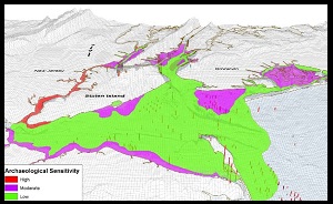

Figure 6: 3-Dimensional view of archaeological sensitivity Figure 7: Composite map of archaeological potential superimposed
model and borings. on bathymetry of the Upper and Newark Bays.
This work will be used to determine the need for further investigations in future dredging projects. The series of studies were synthesized into a report prepared for the New York District by Geoarchaeology Research Associates entitled “Geomorphological and Archaeological Study of New York and New Jersey Harbor Navigation Channels" which may be downloaded here Geomorphology Study.
As part of a federal agency, the New York District is required to identify the cultural resources within a project area and evaluate their eligibility for listing on the National Register of Historic Places (NRHP). The Federal statutes and regulations authorizing the New York District to undertake these responsibilities include Section 106 of the National Historic Preservation Act, as amended and the Advisory Council on Historic Preservation Guidelines for the Protection of Cultural and Historic Properties (36 CFR Part 800). In 2000, the New York District entered into a Programmatic Agreement (PA) with the New Jersey Historic Preservation Office (NJHPO), the New York State Historic Preservation Office (NYSHPO) and the Advisory Council on Historic Preservation (ACHP) for the Harbor Deepening Project. These studies were conducted under stipulations of that PA.
For further information please send us an email.